Drone Property Boundary Video: Visualizing Lot Lines for Real Estate in 2026

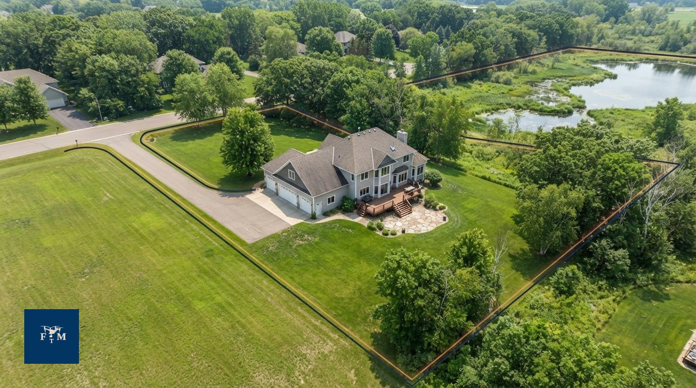
How many serious buyers scroll past your acreage listing simply because they can't tell where the lawn ends and the neighbor's woods begin? Relying on flat plat maps and ground shots creates instant friction. A motion-tracked drone property boundary video solves this spatial puzzle right away, translating abstract property lines into a crisp, cinematic walkthrough that keeps buyers engaged.
You already know that buyers struggle to decode lot sizes from two-dimensional drawings, often leaving irregular parcels sitting on the market far too long. In this guide, you'll discover how dynamic drone property boundary videos clarify parcel dimensions, elevate your marketing presentations, and captivate prospective buyers. We'll examine the motion-tracking technology powering these artistic overlays, detail when to deploy them for acreage or waterfront homes across the Twin Cities, and outline the exact production workflow that turns complex parcels into high-performing listings.
Table of Contents
What Is a Drone Property Boundary Video in Real Estate?
A drone property boundary video blends high-resolution 4K aerial cinematography with motion-tracked graphic overlays to showcase a parcel's perimeter. Rather than freezing a property into a flat, lifeless image, this video format anchors virtual boundary lines directly to the moving terrain. As the aircraft glides, orbits, or banks above the acreage, the line stays pinned to the earth below. The result is an engaging, cinematic tour that instantly clarifies where a property begins and ends.
Traditional marketing often leaves buyers guessing. While standard property photos capture curb appeal, they completely obscure lot dimensions, setbacks, and natural topography. Dynamic aerial boundary video bridges that gap, transforming raw land, hobby farms, and wooded estates into clear visual stories that prospective buyers understand in seconds.
Visualizing Lot Lines Versus Traditional Plat Maps
Static plat maps demand abstract spatial visualization. Most residential buyers cannot look at a two-dimensional tax map and translate raw dimensions into real-world yard space, tree canopies, or elevation changes. Ground-level listing photos do little to help when boundary markers sit hidden deep in mature timber or brush.
Aerial video solves this confusion immediately. A sweeping drone pass pairs authentic property depth with structural perspective, demonstrating how the home sits relative to adjacent parcels, private driveways, and tree lines. While licensed cadastral surveying remains the sole legal authority for defining boundaries, motion-tracked video acts as the ultimate visual translation tool for real estate marketing.
The Core Elements of Motion-Tracked Aerial Footage
High-performing boundary video relies on specialized post-production workflows rather than basic static drawings. Several visual elements turn standard aerial video into a high-converting listing asset:
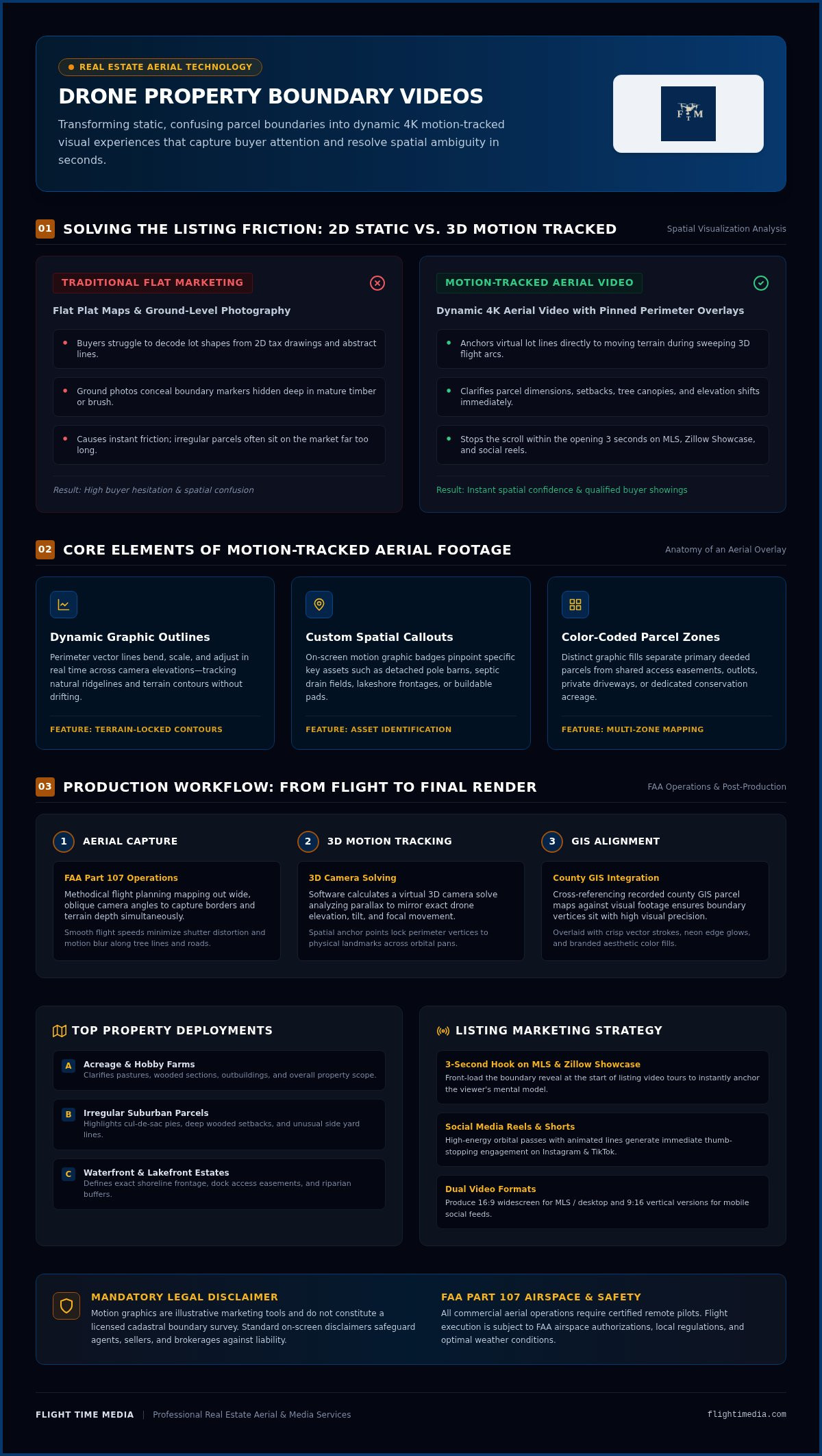
Dynamic Graphic Outlines: Graphic lot lines bend, scale, and adjust in real time across camera elevations, tracking ridgelines and natural contours across moving video frames.
Custom Spatial Callouts: On-screen motion graphic badges pinpoint key property features, such as detached pole barns, septic drain fields, lakeshore frontages, or buildable pads.
Color-Coded Parcel Zones: Distinct graphic fills separate primary deeded parcels from shared access easements, outlots, or conservation acreage.
Integrating these technical visual elements through professional media services gives potential buyers immediate spatial confidence, turning confusing acreage listings into clear, compelling presentations that drive qualified showings.
How Dynamic Aerial Overlays Work: Technology and Production
Producing a seamless drone property boundary video requires a synchronized workflow between on-site piloting and advanced digital tracking. When an aircraft circles a multi-acre property, trees, hills, and structures change perspective continuously. A static graphic pasted over moving video drifts out of place instantly. Precision motion tracking anchors the perimeter directly to the terrain, ensuring the graphic outline looks native to the landscape.
Flight Planning and Aerial Capture Techniques
Stable footage forms the foundation of every trackable shot. Professional FAA Part 107 pilots map out methodical flight paths around the parcel, prioritizing wide, oblique camera angles that capture horizontal borders and terrain depth simultaneously. Operating at smooth, deliberate speeds minimizes shutter distortion and motion blur, leaving clean contrast points along tree lines, fences, and road edges. Naturally, actual flights always depend on weather conditions and FAA airspace authorizations.
3D Motion Tracking and Camera Solving
Back in the editing bay, post-production specialists pass the high-resolution footage into specialized camera-tracking software. The system calculates a virtual 3D camera solve, analyzing real-world parallax to mirror the drone's exact elevation, tilt, and focal movement throughout the flight. Editors place spatial anchor points across identified physical landmarks, locking boundary vertices to the ground across complex orbital pans and sweeping reveals.
GIS Parcel Alignment and Graphic Design
To verify proper placement, technicians cross-reference current county GIS parcel maps against the visual footage. The motion graphics match recorded legal descriptions as closely as an artistic visual allows. Clean vector strokes, subtle neon edge glows, or branded color fills then sweep into view, directing buyer focus straight toward buildable zones, driveways, and natural boundaries.
This technical precision eliminates guesswork for serious buyers reviewing parcels from their screens. If you want to streamline your next acreage or luxury listing, partner with a dedicated aerial cinematography team to handle the capture and tracking from flight to delivery.
When to Use Property Boundary Videos in Property Listings
Boundary confusion stalls sales. When buyers cannot determine what land conveys with a home, hesitation sets in, showings dwindle, and offers come in below expectations. Deploying a drone property boundary video removes spatial ambiguity across specific property categories where acreage, privacy buffers, and lot shapes drive overall market value.
Expansive Acreage and Rural Estates
Buyers touring five to fifty acres in communities like Lakeville or Rosemount can't gauge perimeter limits from a gravel driveway. Dynamic boundary footage traces fenced pastures, outbuilding setbacks, perimeter bridle paths, and private timber in a single continuous flight path. Incorporating these visuals into your comprehensive listing video marketing ensures out-of-town or busy buyers evaluate the true scale of the estate before booking an on-site showing.
Suburban Parcels with Irregular or Heavily Wooded Perimeters
Pie-shaped cul-de-sac lots and rolling parcels often conceal massive backyards behind thick tree canopies. When mature oak lines obscure adjacent yards in suburbs like Plymouth or Minnetonka, buyers frequently underestimate lot depth. Graphic boundary overlays slice through the canopy visually, defining where private lawns end and shared neighborhood outlots begin. Buyers immediately grasp the usable outdoor footprint, turning hidden square footage into a clear selling point.
Waterfront and Lake Living Properties
Lakeshore listings demand absolute clarity because every linear foot of water frontage carries a substantial valuation premium. A drone property boundary video marks precise shoreline spans, seasonal dock placements, and deeded beach easements on busy lakes like Prior Lake or Lake Minnetonka. Clarifying private riparian zones versus communal shoreline access eliminates buyer confusion early, building confidence and accelerating purchase decisions.
Accuracy, Disclaimers, and Compliance: Avoiding Legal Pitfalls
High-end aerial visuals attract buyers, but misrepresenting real estate boundaries carries serious liability. When publishing a drone property boundary video, precision marketing must never cross into unauthorized surveying claims. Operating legally protects your reputation, shields your sellers from misrepresentation disputes, and keeps your marketing compliant with federal and state regulations.
The Crucial Difference Between Marketing Media and Boundary Surveys
Only state-licensed land surveyors hold the legal authority to define, certify, and record boundary lines. A drone boundary outline is an artistic marketing interpretation designed solely for spatial orientation. Drawing an approximate perimeter over moving footage helps buyers visualize acreage scale, yet it cannot serve as legal proof during title disputes or construction planning.
Every commercial video displaying animated perimeters must feature a clear, persistent on-screen disclosure. Use transparent language at the bottom of the frame whenever lines appear:
"Property boundaries shown are approximate visual representations for marketing purposes only. Not certified for legal, engineering, or surveying use."
"Verify all recorded lot dimensions, easements, and setbacks with a licensed land surveyor."
This disclosure eliminates buyer confusion and insulates real estate professionals from post-sale boundary conflicts.
FAA Part 107 Certification and Flight Safety Standards
Federal law strictly requires an FAA Part 107 Remote Pilot Certificate for any commercial drone operation in real estate. Flying without certification carries civil penalties reaching up to $27,500 per violation from the FAA. Professional pilots understand how to verify line of sight, navigate complex air traffic patterns, and manage altitude restrictions under 400 feet.
In the Minneapolis-St. Paul metro, complex Class B controlled airspace surrounding Minneapolis-St. Paul International Airport (MSP) covers dozens of prime suburbs. Because of these safety parameters, not every property can be flown automatically. Commercial pilots must secure automated LAANC airspace authorizations or state permits before launching.
Commercial flights also demand strict adherence to Minnesota state rules, which mandate commercial operator licensing, aircraft registration, and dedicated aviation liability insurance. Local rules apply as well, such as mandatory flight permits through the Minneapolis Park and Recreation Board for park-adjacent operations. Learn more about navigating local aerial regulations in our comprehensive Twin Cities drone photography guide.
Ready to showcase your parcel with fully insured, compliant aerial marketing? Connect with Flight Time Media to ensure your next shoot meets every FAA standard while giving your listing maximum exposure.
Integrating Drone Boundary Video into Your Listing Marketing Campaign
High-impact listing assets deliver maximum return when deployed strategically across multiple marketing channels. A polished drone property boundary video functions as both an MLS-compliant virtual tour anchor and high-converting short-form social content. Pairing dynamic aerial perimeters with smooth interior walkthrough footage creates a cohesive visual narrative that holds buyer attention from their initial online search straight through to the private showing.
MLS Compliance and Digital Listing Syndication
Regional MLS systems enforce strict regulations against agent branding, phone numbers, and watermarks in primary media fields. To ensure seamless listing approval, professional creators output two master edits: a fully compliant unbranded version and a branded cut for personal marketing. Upload the unbranded horizontal file directly to your MLS virtual tour link to syndicate across Zillow, Realtor.com, and Redfin. On your dedicated single-property website, pair dynamic aerial sweeps alongside crisp professional real estate photography to give out-of-market buyers complete confidence in the home and its grounds.
Social Media Distribution and Short-Form Agent Reels
Mobile house hunters decide whether to keep watching in fractions of a second. Hook prospective buyers within the first three seconds by opening your video with an expansive aerial pull-back that draws glowing boundaries across the parcel. Cropping motion-tracked aerial footage into vertical 9:16 aspect ratios creates thumb-stopping reels for Instagram and TikTok. Dive into pacing frameworks, music syncing, and caption strategies with our in-depth guide to agent listing reels.
Selecting the Right Aerial Media Production Partner
Producing accurate boundary animations demands specialized filming techniques, FAA flight authorization knowledge, and advanced 3D motion-tracking capabilities. When vetting a visual media provider, verify the following core qualifications:
Legitimacy and Coverage: Confirm the pilot holds an active FAA Part 107 certificate alongside comprehensive commercial aviation liability insurance.
Production Precision: Look for stable flight motion and clean, jitter-free vector tracking locked precisely to the terrain.
Turnaround Speed: Ensure the team delivers optimized files quickly so your listing hits the market without delays.
Partnering with a proven production team removes the friction from aerial marketing. Explore dedicated aerial packages and video options through Flight Time Media drone services to elevate your listings with market-ready visual clarity.
Transform Your Parcel Marketing with Precision Aerial Overlays
Translating complex lot dimensions into clear visual stories transforms how buyers engage with real estate. A dynamic drone property boundary video removes the guesswork from expansive acreage, lakefront shorelines, and irregular suburban parcels, giving prospective buyers the spatial confidence they need to submit strong offers. When paired with clear marketing disclaimers and compliant flight operations, dynamic aerial video keeps your marketing safe, engaging, and competitive.
Delivering high-impact visual media shouldn't create extra friction for your business. Flight Time Media provides FAA Part 107 certified commercial drone pilots serving Minneapolis, St. Paul, and the surrounding Twin Cities metro. With fast 24-hour turnaround on listing media and precision tracking workflows, turning challenging parcels into standout listings is simple. Elevate your listings with professional aerial media from Flight Time Media and showcase every lot with true visual impact.
Frequently Asked Questions
Is a drone property boundary video legally considered a land survey?
No, a drone property boundary video is an artistic visual representation, not a certified legal survey. Only a licensed land surveyor can legally define or verify property lines. Aerial overlays illustrate approximate scale, acreage, and buffer zones for listing presentations. Buyers and agents should never use graphic overlays for building permits, fence installation, or title disputes. Always recommend consulting a licensed surveyor for definitive boundary verification.
Can drone boundary footage be captured on heavily wooded or sloped lots?
Yes, skilled drone pilots can capture boundary footage over dense timber and steep topography across Minnetonka, Eden Prairie, and surrounding metro areas. Higher flight elevations provide an unobstructed vantage point above dense canopies. Pilots identify natural landmarks, roads, and fence lines to establish clear ground points. During post-production, 3D tracking software accounts for elevation changes, ensuring lines track the terrain realistically despite heavy leaf cover or rolling terrain.
Do real estate agents need an FAA Part 107 license to film drone property lines?
Yes, real estate agents flying drones for commercial listing media must hold an FAA Part 107 Remote Pilot Certificate by federal law. Flying a drone to promote or market real estate is strictly commercial activity, regardless of property size. Operating without certification risks civil penalties reaching up to $27,500 per violation. Twin Cities agents partner with certified aerial providers like Flight Time Media to ensure compliance with airspace authorizations and state insurance mandates.
How are property lot lines accurately aligned over moving aerial video?
Lot lines are aligned by pairing public county GIS parcel data with advanced 3D camera tracking software. Post-production editors cross-reference recorded tax maps with physical landmarks visible in the 4K aerial footage, like road intersections, fences, and tree lines. The software calculates camera position, focal length, and elevation in 3D space, anchoring graphic boundary lines to the terrain so they stay locked as the aircraft maneuvers.
What disclaimer must be included on aerial boundary listing videos?
Listing videos featuring lot line overlays should display a clear visual disclaimer stating the boundaries are approximate. A standard disclosure reads: "Boundaries shown are approximate visual representations for marketing purposes only and are not certified for legal, surveying, or engineering use." Displaying this text at the bottom of the screen while lines appear prevents misrepresentation claims and shields agents and sellers from post-sale legal liability.
Can drone property boundary videos be shared on MLS listing portals?
Yes, a drone property boundary video can be added to MLS listings, provided it complies with unbranded virtual tour guidelines. Regional MLS platforms, along with syndication portals like Zillow and Realtor.com, require media files free from agent contact info, broker logos, or promotional watermarks. Delivering an unbranded horizontal cut alongside branded cuts for social channels ensures compliance across every digital real estate platform.
How long does it take to produce a motion-tracked aerial boundary video?
Most professional listing media teams deliver completed motion-tracked aerial boundary videos within two to three business days. While standard real estate photography packages from Flight Time Media feature a fast 24-hour turnaround, motion-tracked video requires extra post-production steps for 3D camera solving, GIS alignment, and graphic rendering. Booking shoots a few days before your launch date ensures your acreage listing hits the market right on schedule.


Comments