Minneapolis Drone Photography: Sell Listings Faster (2026)

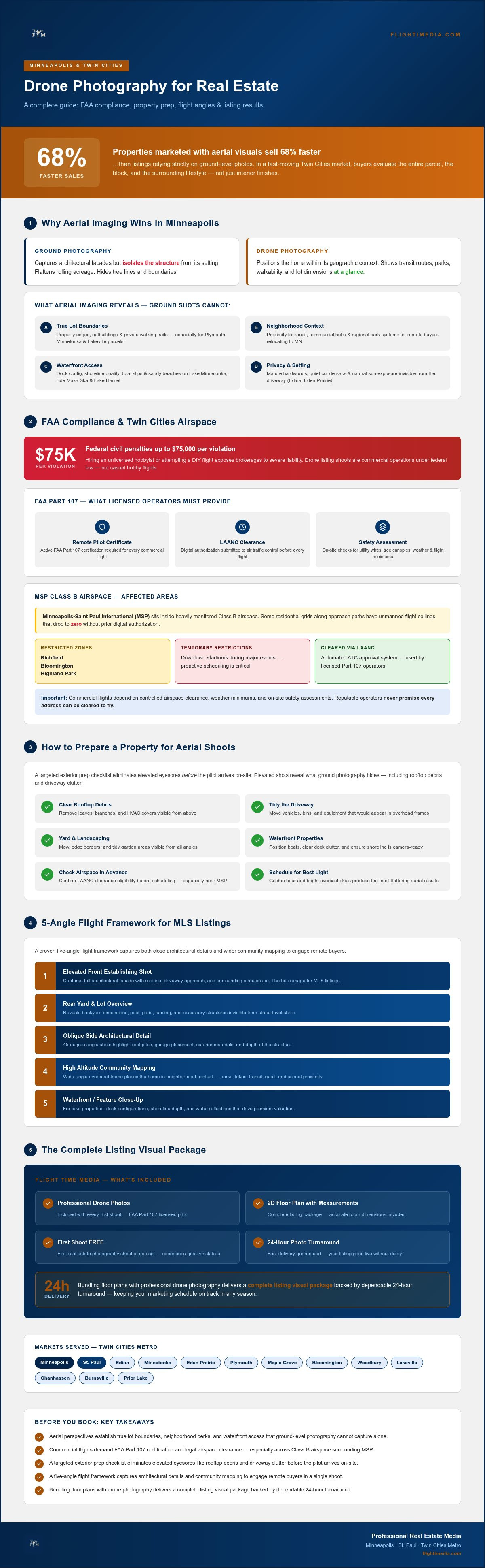
Properties marketed with aerial visuals sell 68% faster than listings relying strictly on ground-level photos. In a fast-moving Twin Cities market, serious buyers don't just evaluate interior finishes; they buy the entire parcel, the block, and the surrounding lifestyle. Investing in professional drone photography Minneapolis agents trust is the fastest way to showcase true lot dimensions, mature tree canopies, and lake proximity. Still, coordinating flights around unpredictable Minnesota seasons and strict FAA airspace restrictions near MSP often creates unwanted hesitation for busy listing agents.
You shouldn't have to guess whether a flight is compliant or stress over delayed marketing schedules to give your sellers an edge. Discover how licensed aerial imaging elevates Twin Cities property listings, navigates strict airspace regulations safely, and drives real buyer action. Below, you'll learn how to prepare your property, verify Part 107 compliance, and schedule a seamless aerial shoot with guaranteed 24-hour turnaround.
Table of Contents
Why Minneapolis Real Estate Listings Demand Strategic Drone Photography
Navigating FAA Regulations and Airspace in the Twin Cities Metro
How to Prepare a Twin Cities Property for an Aerial Shoot: Step-by-Step
Selecting the Essential Drone Angles for High-Converting MLS Listings
Booking Professional Twin Cities Aerial Media: Fast Turnaround & Integrated Packages
Why Minneapolis Real Estate Listings Demand Strategic Drone Photography
Twin Cities buyers evaluate neighborhood infrastructure just as closely as kitchen updates. Standard ground-level photography captures architectural facades, but it completely isolates the structure from its setting. Professional real estate aerial imaging bridges that visual gap, positioning a home within its wider geographic context. Incorporating high-resolution drone photography Minneapolis agents rely on reveals proximity to major transit routes, immediate walkability to commercial hubs, and accessibility to regional park systems.
While the broader history of aerial imaging originated as a tool for strategic mapping, modern real estate media adapts those high-angle vantage points to solve a specific buyer problem: friction in spatial comprehension. Buyers relocating from outside Minnesota cannot simply tour the neighborhood on foot. Elevated imaging delivers instant visual answers by displaying the surrounding community landscape in seconds, keeping remote prospects engaged on MLS listings and social feeds longer.
Visualizing Lot Boundaries and Surrounding Twin Cities Topography
Large suburban parcels require elevated perspective to communicate usable space. For expansive properties in Plymouth, Minnetonka, or Lakeville, ground shots flatten rolling acreage and hide tree lines. Strategic aerial frames outline true property boundaries, detached outbuildings, and private walking trails. In established settings like Edina or Eden Prairie, elevated perspectives show how a home nestles among mature hardwoods and quiet cul-de-sacs, giving buyers a clear sense of privacy before setting foot on site.
Elevating Waterfront and Lake Living Listings
Water-oriented properties demand deliberate aerial composition to drive premium valuation. Minnesota living revolves around the water, and buyers want immediate proof of how a property interfaces with the shoreline:
Dock Configuration and Shoreline Quality: Showcase lake frontage depth, boat slips, and sandy beaches across Lake Minnetonka bays.
Scenic Basin Orientation: Capture broad sightlines across South Minneapolis hotspots like Bde Maka Ska and Lake Harriet.
Natural Sun Exposure: Frame western orientations and water reflections that remain completely invisible from the driveway.
Elevating the camera transforms lake living into an experiential narrative, proving clear recreational value and accelerating listing momentum across competitive regional channels.
Navigating FAA Regulations and Airspace in the Twin Cities Metro
Flying a drone to market real estate isn't a casual hobby; it's a commercial operation under federal law. Every listing shoot requires adherence to strict FAA Part 107 rules, which mandate that pilots hold an active Remote Pilot Certificate. Hiring an unlicensed hobbyist or attempting a DIY flight exposes brokerages to severe liability. With federal civil penalties reaching up to $75,000 per violation, regulatory compliance is non-negotiable for reliable drone photography Minneapolis teams can depend on. Commercial flights depend on controlled airspace clearance, weather minimums, and on-site safety assessments; reputable operators never promise that every single address can be cleared to fly.
Understanding Local Airspace Restrictions and Class B Zones
Minneapolis-Saint Paul International Airport (MSP) sits inside heavily monitored Class B airspace. This footprint imposes strict altitude ceilings on residential neighborhoods across Richfield, Bloomington, and Highland Park. In several flight grids directly along approach paths, unmanned flight ceilings drop to zero without prior digital authorization. Certified operators use the Low Altitude Authorization and Notification Capability (LAANC) system to submit flight plans and secure automated clearance from air traffic control. Flights must also route around temporary flight restrictions over major downtown sports stadiums during events, making proactive scheduling critical.
Liability, Safety Protocols, and Professional Risk Mitigation
Managing operational risk protects both the listing agent and the homeowner. Urban neighborhoods feature tight lot lines, overhead utility wires, and mature tree canopies that demand structured pre-flight checks and visual observers. Partnering with an FAA Part 107 licensed operator ensures your visual marketing complies with federal registration, Remote ID mandates, and verified commercial liability coverage.
Take time to review our comprehensive Twin Cities drone photography guide to see how we navigate complex regional flight corridors. When you want compliant marketing without the legal headaches, explore our streamlined professional media services to keep your launch moving forward safely.
How to Prepare a Twin Cities Property for an Aerial Shoot: Step-by-Step
High-altitude lenses capture every detail within the property boundary. Ground-level staging tips fall short because elevated viewpoints expose clutter hidden behind privacy fences, along roof valleys, and across patio surfaces. Insights published by the National Association of REALTORS® highlight how visual presentation directly influences listing engagement and online buyer impressions. Executing a structured preparation plan prevents costly re-shoots and guarantees polished drone photography Minneapolis buyers will notice instantly.
Eliminating Overhead Clutter and Driveway Obstructions
A pristine driveway sets the tone for your exterior hero images. Complete these essential clean-up tasks at least two hours before your media appointment:
Clear All Vehicles: Park cars inside closed garages or move them completely down the street, away from the listing facade.
Conceal Utility Equipment: Stow trash bins, recycling carts, garden hoses, children's toys, and pet gear out of sight.
Clear Auxiliary Surfaces: Remove tarps, lawnmowers, ladders, and pool covers that create visual clutter from above.
Maximizing Grounds Appeal and Exterior Lighting
Meticulous yard maintenance produces crisp, clean lines on camera. Schedule lawn mowing, leaf blowing, or snow clearing roughly 24 hours prior to the flight to avoid fresh clipping tracks or muddy footprints across the turf. Power-wash deck surfaces, sweep patio pavers, and position outdoor furniture cushions symmetrically. Turn on all exterior architectural facade lighting, porch fixtures, and landscape spotlights. Even under broad daylight, illuminated fixtures add warmth and dimensional contrast against brick, cedar, or stone siding.
Informing Neighbors to Ensure Seamless Shoot Execution
Unannounced drone flights frequently trigger neighbor curiosity or misplaced privacy concerns. Send a quick text or leave a polite door hanger notifying immediate neighbors about the 30-minute aerial media window. Clarify that the camera focuses exclusively on your client's parcel to highlight its architectural appeal and lot layout. For a full checklist covering interior staging and curb appeal alignment, explore our detailed real estate photography guide.
Selecting the Essential Drone Angles for High-Converting MLS Listings
Capturing effective aerial media requires disciplined composition rather than random snapshots from maximum altitude. Skilled pilots rely on a proven five-shot framework that balances architectural structure with geographic positioning. Altitude variation dictates the story: flights between 20 and 40 feet emphasize building design, while elevations near 150 feet document parcel context. In northern latitudes like Minnesota, solar trajectory heavily impacts the final image. Low winter sun creates dramatic long shadows across snowdrifts, while midday summer sun causes blinding glare on dark asphalt shingles. Timing flights to account for sun angles and seasonal foliage ensures your exterior media blends seamlessly with your interior listing visual services.
The Elevated Front Elevation and Architectural Hero Shot
Hovering just 20 to 40 feet off the turf produces a powerful architectural hero shot that standard tripods cannot match. This sweet spot captures the full scale of two-story homes without distorting vertical gables or flattening roof pitches. The camera stays level with the upper fascia, looking slightly down toward the front entry. This height keeps the front door inviting while framing the property against mature tree canopies, providing an immediate upgrade over standard curb-level photography.
The 45-Degree Overview and Contextual Top-Down Map
Higher angles reveal structural layout, outdoor entertainment zones, and landscape integration:
The 45-Degree Rear Perspective: Position the aircraft at 60 to 100 feet to capture back patios, multi-tier decks, and swimming pools in a single frame.
The Top-Down Parcel Map: Aim the gimbal directly downward at 90 degrees to showcase exact lot dimensions, property lines, and hardscape design.
The Horizon Context Shot: Elevate to 150 feet with the camera tilted toward the horizon, visually connecting the home to Minneapolis skyline views, nearby lakes, or regional transit corridors.
Every angle serves an intentional marketing purpose that guides prospective buyers through the listing before they schedule an in-person showing. To capture these high-converting perspectives on your next listing, partner with Flight Time Media for comprehensive aerial coverage.
Booking Professional Twin Cities Aerial Media: Fast Turnaround & Integrated Packages
Coordinating separate vendors for interior photography, schematic floor plans, and aerial footage creates unnecessary friction and threatens tight listing deadlines. Bundling interior stills, floor plans, and aerial perspectives into a single site visit streamlines production from day one. Investing in unified drone photography Minneapolis agents trust delivers consistent color grading, synchronized delivery, and single-source accountability.
1. Instant Online Scheduling: Select your media bundle, pick your preferred shoot window, and submit the listing address online.
2. Airspace & Site Verification: Our FAA Part 107 certified team reviews local flight grids, weather minimums, and MSP airspace clearances before arrival.
3. Single-Visit Production: An experienced professional completes the interior photography, exterior grounds capture, and drone flight during one efficient appointment.
4. Rapid Delivery: Access your MLS-ready assets, marketing files, and floor plans within 24 hours of shoot completion.
Unlocking Frictionless Scheduling and Rapid 24-Hour Delivery
Listing timelines across Hennepin and Ramsey County move quickly, especially when preparing for a high-traffic Thursday MLS launch. We eliminate administrative lag with a guaranteed 24-hour turnaround on all real estate photos. You receive two organized download folders: MLS-optimized digital exports sized for instant portal upload, and high-resolution print files for luxury marketing flyers. This dependable workflow removes multi-vendor handoffs so you can focus on seller communication and open house prep.
Leveraging Introductory Twin Cities Listing Packages
Testing a new media partner shouldn't disrupt your marketing budget. Qualifying Twin Cities agents can evaluate our field operations directly with their first real estate photography shoot free. This complete introductory package integrates full interior coverage, FAA-compliant drone photography Minneapolis properties need to stand out, and an accurate 2D floor plan with verified room measurements. Discover our technical standards and field experience on our about page, or schedule your upcoming listing directly with Flight Time Media today.
Accelerate Your Twin Cities Listing Momentum Today
Winning buyer attention in a fast-paced market requires presenting more than just interior spaces. High-impact aerial media defines lot boundaries, highlights neighborhood assets, and positions homes for maximum reach across MLS feeds. Working with an FAA Part 107 certified commercial pilot keeps your brokerage fully compliant while navigating complex regional flight paths safely.
Streamline your listing launch with unified media production. Pair elevated views with detailed interior captures and accurate 2D floor plans with measurements to give buyers a complete spatial understanding. Backed by a guaranteed 24-hour turnaround on listing photos, you can launch marketing campaigns right on schedule without the friction of managing multiple vendors.
Give your sellers a decisive competitive advantage. Claim your first real estate shoot free with drone photos included and discover how high-caliber drone photography Minneapolis buyers respond to can transform your listing performance.
Frequently Asked Questions
Can every residential property in Minneapolis be photographed using a drone?
No, not every residential property can be legally or safely photographed from the air. Flight operations depend entirely on FAA airspace restrictions, local tree canopies, overhead utility lines, and current weather. Locations situated directly along primary approach paths near MSP International Airport may face zero-altitude restrictions that prevent takeoffs. Professional pilots assess every address in advance through digital clearance systems to confirm flight feasibility and maintain total safety.
Do you need a special permit to fly commercial drones over Twin Cities homes?
Yes, commercial aerial operations require an FAA Part 107 Remote Pilot Certificate rather than a recreational hobbyist registration. Professional drone photography Minneapolis listing shoots also require real-time LAANC airspace authorizations when operating inside controlled zones near airports. Individual municipalities or park boards may also enforce local takeoff rules on public land. Hiring a licensed pilot ensures all airspace authorizations and legal liability protocols are handled correctly.
How quickly will I receive my edited aerial photos after the shoot?
You will receive your fully edited aerial photos within 24 hours of shoot completion. Fast delivery ensures listing agents can finalize MLS uploads and marketing materials without missing tight launch deadlines. All media files arrive organized into two separate digital download folders: web-sized images optimized for MLS portals and high-resolution files formatted for print flyers and luxury brochures.
What happens if it rains, snows, or is excessively windy on the shoot date?
Flights are promptly rescheduled to the next available clear weather window if adverse conditions arise. Commercial drones cannot safely operate in active precipitation, heavy snow, thick fog, or sustained winds above manufacturer limits. If the weather looks questionable, we monitor local forecasts closely and coordinate with you to shift the aerial appointment, ensuring the final imagery features bright, clear skies and crisp contrast.
How many drone photos are typically included in a real estate listing package?
Most standard real estate media packages include between five and ten high-resolution aerial photos. This curated collection covers every essential exterior perspective, including low-altitude architectural front elevations, elevated rear yard compositions, top-down parcel maps, and wide horizon shots showcasing neighborhood context. That quantity provides complete visual coverage for MLS listings without overwhelming buyers with repetitive or redundant high-altitude angles.
Can drone photography show property boundaries on acreage lots in outer suburbs?
Yes, aerial imaging is the most effective visual tool for outlining acreage boundaries on properties across suburbs like Lakeville, Minnetonka, or Plymouth. Top-down bird's-eye captures and elevated diagonal angles clearly display fence lines, natural wood lines, driveways, and detached structures. Real estate drone photography Minneapolis agents utilize often pairs these high-altitude perspectives with digital lot line overlays to give prospective buyers immediate clarity on usable land.
Does an agent or homeowner need to be present during the aerial shoot?
No, neither the listing agent nor the homeowner needs to remain on-site during an exterior aerial shoot. As long as vehicles are cleared from the driveway, outdoor clutter is stowed away, and access to the exterior grounds is unobstructed, the pilot can complete the flight checklist autonomously. We review site details and flight plans beforehand to ensure a seamless, independent capture process.


Comments