Twin Cities Commercial Property Drone Imaging Guide
Updated: Sep 30
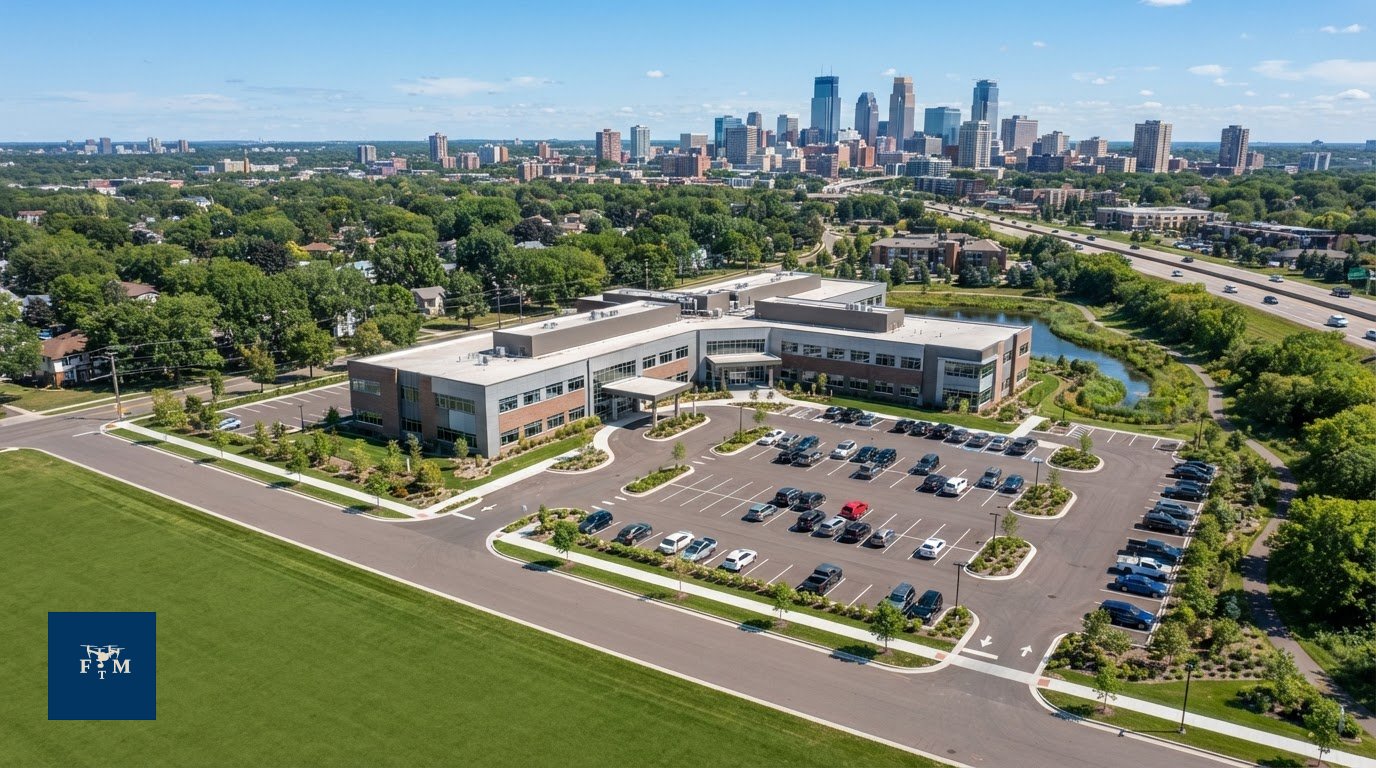
An aerial image can look dramatic and still leave a commercial property’s biggest questions unanswered. Effective commercial property drone imaging shows how a site connects to visible roads, where entrances and parking are located, and how the building fits within its surroundings.
Choosing the right views can be challenging. Tenants, buyers, and investors may need different details, while weather and airspace can affect the plan. Start with the audience and the questions they need answered, then match the flight and deliverables to those priorities.
This guide explains how aerial stills and video can communicate a property’s context, access, scale, and visible features. It also covers planning a shoot in Minneapolis, St. Paul, and the Twin Cities, including flight feasibility, airspace, weather, and on-site safety. Flight Time Media provides drone imaging through an FAA Part 107 licensed operator. Each operation is subject to location-specific requirements and conditions.
Table of Contents
What commercial property drone imaging can show beyond ground-level photos
Commercial property drone imaging is aerial still photography or video created to help market a property by showing its site, building, access, and surroundings from an elevated viewpoint. The camera platform is an Unmanned aerial vehicle (UAV), but the marketing value comes from choosing views that answer real questions about the property, not simply flying higher.
Ground-level photos show entrances, facades, and close details. Aerial views add a broader perspective, helping viewers see how the building sits on the parcel, how visible areas connect, and what features surround it. This context can support a prospective tenant’s, buyer’s, or investor’s understanding, but it isn’t a survey, inspection, appraisal, or guarantee of property conditions.
Which commercial property details are easier to understand from above?
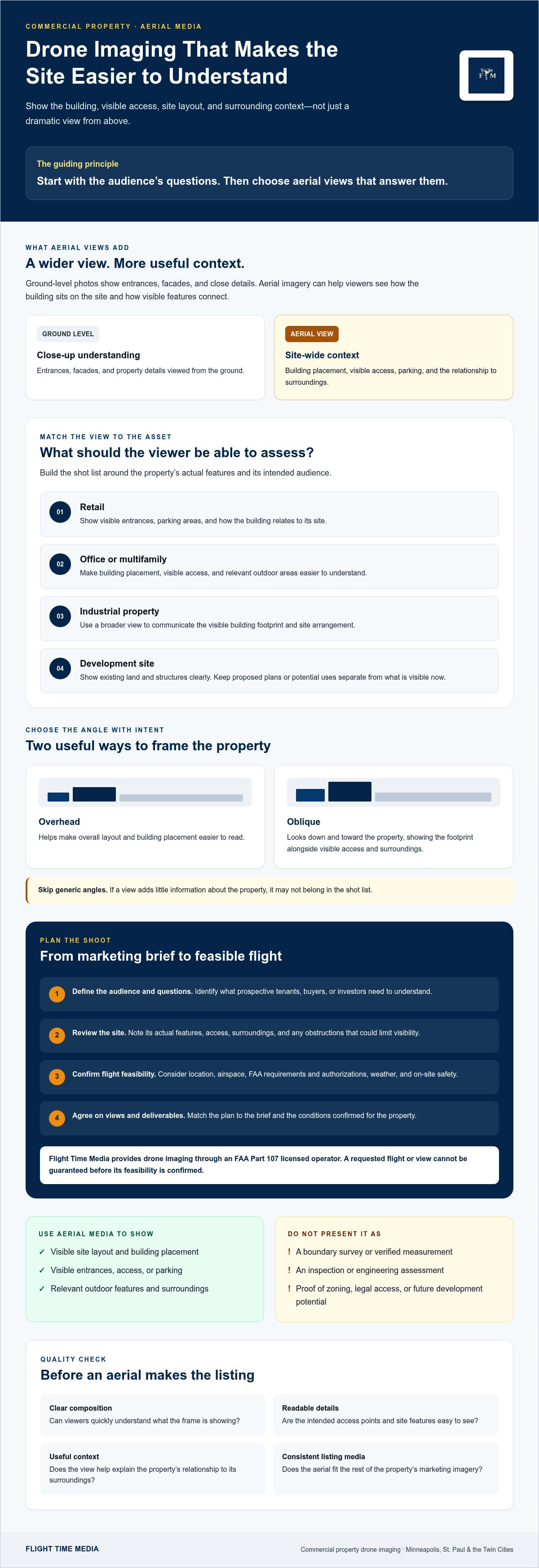
An overhead view can make the overall layout and building placement easier to read. An oblique angle, captured from above and toward the property, can show the structure’s footprint alongside visible access points and surrounding context. Choose views based on the property’s actual features and what its audience needs to understand.
Retail: Show visible entrances, parking areas, and the relationship between the building and its site.
Office or multifamily: Show the building’s placement and outdoor areas when those features matter to the marketing.
Industrial or development site: Provide a broad view of the building or visible site layout. Don’t imply an image verifies parcel boundaries or development capacity.
For a Bloomington property, parking, landscaping, or an outdoor amenity may merit aerial coverage when it’s present and relevant to the listing. Avoid a generic shot list. Identify the site’s actual features first, then choose angles that make them easy to see.
What drone imagery cannot establish on its own
Aerial marketing imagery provides visual context, not technical documentation. It doesn’t replace a boundary or land survey, engineering assessment, property inspection, or verified measurements. A photograph alone can’t establish legal boundaries, zoning, occupancy, building condition, or future development potential.
Keep marketing claims aligned with what the frame visibly shows. A view may illustrate an access point or outdoor area, for example, but it doesn’t confirm legal access or the feature’s condition. Roofs, landscaping, adjacent structures, and other obstructions can limit visibility. Weather and flight feasibility also affect which angles can be captured, so not every requested view will be possible. Flight Time Media’s real estate media services include drone imaging. Each operation is subject to airspace, FAA requirements and authorizations, weather, location, and safety.
Matching Commercial Drone Imaging to the Asset
A useful shot list starts with the asset’s marketing objective, not a standard set of angles. Let the property’s marketing objective determine the shot list. An occupied office building may need a clear view of access and its position on the site. A development listing may benefit from a broad view of existing land and structures, without suggesting that proposed plans or future uses are already in place.
Choose aerial views around the property’s purpose
Match each view to a question a prospective tenant, buyer, or investor is likely to have. Aerials should clarify the property, not add decoration without a purpose. For Bloomington listings, plan around the actual site features and intended audience instead of assuming every property needs the same coverage.
Retail: Would viewers benefit from seeing the building in relation to visible parking and entrances? Consider an elevated still that includes those elements.
Office: Does the listing need to orient viewers to the building’s placement and visible access? Choose an angle that makes the site context easy to follow.
Industrial: Would a wider view help communicate the building footprint and visible site arrangement? Keep the image focused on what can be seen.
Multifamily or mixed-use: Prioritize exterior context and outdoor areas that matter to the listing. Skip aerial coverage that adds little information.
Development site: Show the existing property clearly. Keep conceptual plans and potential uses distinct from current, visible conditions.
Decide whether to commission aerial photos, video, or both
Stills work well when the priority is a clear, reusable view for a listing page, brochure, or other marketing material. Video can orient viewers through a planned sequence, such as moving from a wider site view toward the building. It’s most useful when that progression adds context a single frame can’t provide. Commission both formats only when each has a distinct role.
Audience question | Useful view | Possible deliverable
How is the building positioned? | Elevated view of building and site | Aerial still
Where are visible access points? | Oblique view that includes relevant approaches | Aerial still or short video sequence
How does the site come together? | Planned movement from broad context toward key areas | Aerial video
For practical guidance on selecting aerial coverage, see Flight Time Media’s Twin Cities drone photography and videography services. A qualified operator should also be prepared to discuss applicable FAA commercial drone regulations and confirm which requested views are feasible for the specific property.
Commercial drone imaging: how to assess usefulness, quality, and limitations
A polished aerial view still needs to serve a purpose. Review each proposed frame or sequence against the listing’s marketing goal: does it make the building easier to understand, clarify a site feature, or orient viewers to the property? If it adds no useful information beyond the existing ground-level photos, it may not belong in the final set.
What makes an aerial image useful to a property audience?
Look for a clear subject, an intentional angle, and enough context to understand where the building sits. A parking area or entrance can be relevant, but not if it dominates the frame and makes the property hard to read. Check that listing-relevant details remain visible and that the view complements, rather than competes with, ground-level photography.
Composition: Is the building or site the obvious subject, with distracting elements kept secondary?
Legibility: Can viewers distinguish the features the image is meant to show?
Context: Does the angle explain the property’s placement without implying facts the image can’t verify?
Added value: Does this view reveal something the existing listing photos don’t?
Compare aerials with the rest of the property media. Consistent color, exposure, and visual tone help the listing feel cohesive. The goal isn’t to make an aerial image look identical to an interior photograph, but to make each format feel like part of the same considered presentation.
When a combined photo and video plan makes sense
Use stills and video together only when each has a distinct role. A still can provide a direct, reusable overview of the site. A planned video sequence may help viewers follow a route or understand how visible areas relate. If the sequence simply repeats what the still communicates, choose the format that best serves the listing.
Think about the full media flow. Interior images can explain the spaces; ground-level exterior photography can show entrances and architectural details; aerial media can establish broader context. Listing video can connect those perspectives when a deliberate sequence improves the story. For more on coordinating formats, consult a Twin Cities listing video marketing resource.
Ask the provider to explain the purpose of each proposed view and how it fits the deliverables. Flight Time Media’s drone work is performed by an FAA Part 107 licensed operator. The FAA’s guidance on commercial drone operations is a useful reference, but certification doesn’t mean every property or requested shot is feasible. Confirm the plan for the specific location and conditions.
How to plan a commercial property drone shoot in Bloomington and the Twin Cities
A clear plan starts with the marketing goal, then checks what’s practical at the specific site. For commercial property drone imaging in Bloomington or elsewhere in the Twin Cities, work through these steps before settling on a shot list or schedule.
Define the brief. Share the property address, asset type, intended audience, and marketing purpose. Explain what viewers should understand after seeing the aerial media.
Prioritize the views. Identify features that matter, such as building placement, visible access points, parking, or outdoor amenities. Separate essential views from nice-to-have angles.
Share site and access details. Confirm how the operator can access the property and identify an on-site contact. Flag timing needs or coordination requirements in advance.
Review flight feasibility. The operator assesses the location and requested views before confirming a flight plan. An FAA Part 107 licensed operator does not mean every requested flight or angle is possible.
Confirm the plan and deliverables. Clarify which stills or video are feasible, the expected timing, and how the final media will be delivered. Keep the plan flexible until those details are confirmed.
What affects flight feasibility and shoot-day decisions?
Airspace, FAA requirements, any required authorizations, weather, location, and safety all affect whether and how a flight can proceed. Conditions at the property may also limit a requested viewpoint or change the workable shot list. Don’t assume a preferred date, authorization, or aerial angle is confirmed until the operator has assessed the specific circumstances.
On the shoot day, the operator should make decisions based on current conditions and the approved plan. If a requested view isn’t feasible, discuss alternatives that still support the marketing objective. A different angle or a ground-level view may be a useful fallback, depending on the property and what can be safely captured.
What to have ready before you book
Prepare the address, property details, access arrangements, priority features, and audience questions in one brief. This helps the media provider evaluate the request and identify what needs confirmation before scheduling. Flight Time Media provides drone imaging through an FAA Part 107 licensed operator, with each operation subject to the property’s circumstances and applicable requirements.
Flight Time Media serves commercial property clients in Minneapolis, St. Paul, Edina, Minnetonka, Eden Prairie, Plymouth, Maple Grove, Bloomington, Woodbury, and Lakeville. For service details and to discuss property-focused aerial coverage, review Flight Time Media’s Twin Cities drone photography and videography. Confirm feasibility, requested views, access, timing, and deliverables for the specific property before finalizing the shoot.
Choosing a commercial property drone imaging partner for your listing
The right partner should do more than operate a drone. They should understand how aerial photos or video fit the property’s marketing plan, communicate constraints early, and confirm exactly what you’ll receive. Use this checklist to compare providers:
Property-media experience: Can they explain how they’d tailor aerial views to your asset type and audience?
Flight planning: Will they assess the specific location and explain how airspace, FAA requirements, authorizations, weather, and safety may affect the plan?
Clear communication: Can they confirm property access, requested views, timing, and any details needed from your team?
Deliverable fit: Do the proposed stills, video, or combination support your listing goals, and are the deliverables clear before scheduling?
Ask the operator to walk through the shot list and identify the priority views. Confirm what’s feasible for the property before relying on a particular angle, date, or deliverable. An FAA Part 107 licensed operator brings relevant credentials, but those credentials don’t mean every requested flight is possible.
Questions to ask before booking commercial aerial media
Ask how each proposed view will serve the listing’s audience. Find out how site-specific airspace, authorization needs, weather, and safety will be assessed, and what could change the plan. Then confirm whether you’re booking aerial stills, video, or both, along with access arrangements, timing, and delivery details. Clear answers help prevent mismatched expectations.
How Flight Time Media fits into a wider listing media plan
Flight Time Media serves Minneapolis, St. Paul, Edina, Minnetonka, Eden Prairie, Plymouth, Maple Grove, Bloomington, Woodbury, and Lakeville with real estate photography, videography, and drone imaging. Drone work is performed by an FAA Part 107 licensed operator, and each flight depends on the property’s location and operating conditions. Aerial coverage can be planned alongside other listing media when it serves a distinct purpose.
Flight Time Media’s stated offer is the first real estate photography shoot free, including drone photos. Confirm the offer’s current availability and terms before booking. To discuss a property, requested views, and possible flight feasibility, review Flight Time Media’s Twin Cities drone photography and videography and share the property details.
Plan aerial media around the property’s story
Strong commercial property drone imaging answers practical questions about the site, building, and access rather than relying on dramatic views alone. Match the shot list to the asset and audience, then choose stills, video, or both based on what each format adds to the marketing plan.
Before booking, share the property details, priority views, and access needs. Confirm flight feasibility, timing, and deliverables with the operator. An FAA Part 107 licensed operator can help assess the plan, but airspace, FAA requirements, authorizations, weather, location, and safety mean not every requested flight is possible.
Flight Time Media provides real estate photography, videography, and aerial imaging across the Twin Cities. The first real estate photography shoot is free and includes drone photos; confirm current offer availability and terms before booking.
Ready to plan property-focused media? Discuss your commercial property media needs with Flight Time Media and take the next step with a clear, coordinated plan.
Frequently Asked Questions
What is commercial property drone imaging?
Commercial property drone imaging is property-focused aerial photography or videography created to support marketing. Elevated views can help prospective tenants, buyers, or investors understand a building’s position on its site, visible access points, surrounding context, or relevant outdoor features. The right views depend on the asset and its marketing purpose. Aerial imagery is visual marketing material, not a survey or inspection, and can’t verify measurements or property conditions.
Can a drone photograph every commercial property?
No. A drone flight isn’t possible or appropriate at every property, and the requested views may not all be feasible. The operator must assess the specific location and flight plan, including airspace, FAA requirements, authorizations, weather, and safety. Share the property address and priority views early. The operator can then confirm what may be captured under the site’s circumstances instead of promising a flight or angle before assessment.
Is commercial drone imaging useful for an office or retail property?
It can be useful when an aerial view helps explain a building’s placement, site layout, access, or relevant exterior features. For an office, that might mean showing how the building sits within its visible surroundings; for retail, a view may help communicate the relationship between the building and visible parking. Choose shots for the property and intended audience. Ground-level photography may still be needed for entrances, facades, and closer details.
What is the difference between commercial drone photos and drone video?
Drone photos are individual still views that can present a property’s context or a specific visible feature. Drone video can show a planned sequence, helping viewers move from a broad site view toward the building or another relevant area. Neither format is automatically necessary for every commercial listing. Choose based on the marketing brief: commission video when movement adds useful orientation, and stills when clear, reusable views meet the need.
Do commercial property drone operators need FAA Part 107 certification?
Flight Time Media provides drone photography and videography through an FAA Part 107 licensed operator. If you’re comparing providers, ask who will operate the drone and confirm their relevant credentials. A license doesn’t guarantee that a specific property can be flown or that every requested view is available. Airspace, FAA requirements, authorizations, weather, location, and safety still affect whether a particular flight can proceed.
How should I prepare a commercial property for drone imaging?
Start with the property address, asset type, marketing purpose, intended audience, and access details. List priority features and requested views, then coordinate an on-site contact if needed. These details help the operator assess the request, but don’t confirm a flight by themselves. Flight Time Media serves Minneapolis, St. Paul, Edina, Minnetonka, Eden Prairie, Plymouth, Maple Grove, Bloomington, Woodbury, and Lakeville. Confirm feasibility, timing, and views before finalizing the plan.
Should I book aerial photos, aerial video, or both for a commercial listing?
Choose aerial photos when clear, reusable views are the priority. Consider video if a planned sequence adds context or helps viewers understand how parts of the site relate. Both can fit when each format has a distinct role in the listing’s media plan. Base the choice on the property, intended audience, and marketing brief, then confirm flight feasibility. There’s no need to request every format if one will answer the audience’s questions.
Ready to plan aerial media for a commercial property in the Twin Cities? Contact Flight Time Media to discuss the property, priority views, and a coordinated listing media plan.

Comments